}); }); ]).push({}); }); Jkaf India By Pushpendra Kumar

Friday 27 July 2018


The word ‘GURU’ has its roots in the Sanskrit language, where ‘gu’ means darkness and ‘ru’ stands for the removal of darkness. This day first time comes in word when the Lord SHIVA or First YOGI introduced Saptarishis, the seven celebrated sages. 

GURU PURNIMA_ Lord Shiva and Maharishi VYASH

Day fifteen of Ashadh Sukla is called GURU Purnima. On this occasion we have worship of our Guru who provide us the knowledge about this mighty world and who truly introduce us to our self. This day is celebrated on the name of Maharishi Vayas who wrote the Mahabharata. He was also wrote our all four Vedas. Guru Purnima is in honour of the guru in the form of yogis and sage who help an individual connect on a spiritual level.  On this Guru Purnima the largest Moon ellipse is also can be seen which can be observed in night on 27.07.2018.

Our all Garanthas told us about the importance of GURU. Our life can not be successful without a True GURU. We can differ in views and opinion about God but not to Guru. In India all religion accepts the importance of GURU. So wish to all of you, a Happy Guru Purnima. 


Friday 6 July 2018

Road subsidence at km. 104 Kud-Patnitop, Jammu and Kashmir,


Road subsidence at km. 104 Near Kud-Patnitop, Jammu and Kashmir, Prepared by Pushpendra Kumar, Deputy Manager, Geology,  Rodic consultants Private  Limited, RAMBAN-BANIHAL
Disclaimer: Any part of this report should not be used, updated in any form without the prior permission of the Author.

This report included the following CONTENTS

1. Introduction 
2. General Geology of the Site
3. Visually Inspection of Site and Problem observed
4. Proposal for Stabilization Measures
5. Conclusion


1.Introduction: Cheneni to Patnitop highway passes through rough and steep terrain of lower Himalayas. The kud land slide location falls at 33°05´ 15.04”N and 75° 18´ 8.6”E at km 104 on Cheneni to Patnitop highway. Geologically the area falls under Muree structural belt of Lower Himalayas which is named on Muree, located in Pakistan. The area is tectonically very sensitive due to Muree and Panjal Thrust and very prone to slope failure during snow time and rainy season.

Subsidence at Jammu to Patnitop Highway, Lower Himalaya


2.General Geology: General Geology of the area belongs to rocks of Lower Muree formation comprises a sequence of interbedded sandstone and siltstone/claystone layers, Lower tertiary in age. The tectonic domain of this area is bounded by main frontal thrust (MFT) in south and main boundary thrust in north (MBT). Along the nallah, red clay stone is exposed which is highly weathered on surface and much fined grained. The Rock exposures along the nallah have dipped towards NE direction. The strike of rock unit is sub-parallel to the nallah and road at this location.
Sequence of interbedded sandstone and siltstone/claystone 


This the Arial view of the site which is prepared with the help of google map. The map shows the existing protection works related to old slide. The main causes of this subsidence exactly decided after details Geo technical investigation but at the site it seems that it is triggered due to toe cutting of the slope by flooded water during monsoon.

Arial view of Site from Google Map

3.Visually Inspection of Site and Problem observed: The site have been visited on June 26,2018. It have been observed that the area is under slope instability from long time and some protection measure already adopted at this location as concrete retaining wall and Gabion Wiremesh structure. The current subsidence is occurred due to Toe erosion/Scouring of bed level in the nallah during rain. Due to toe erosion of side slope of the nallah, the creep movement is triggered. Tilted tree at the slope is an indication of slow mass movement at this location. It is also define the lateral boundary of creeping area.

Rain Cut Below  foundation Of RCC cladding wall

Above photograph shows the toe cutting of existing wall due to flood water on bed level. It should be repaired immediately to avoid further damage to the road.

Second problem is observed at existing Culvert and culvert return wall which are damaged badly due to erosion of exposed clay stone. Some cracks are already noticed at floor and side wall of the existing culvert. So it is immediately needs to be repaired without further delay.
Damaged Culvert and Guard wall

     Photograph shows the cracks which are developed at floor and side wall of the culvert.
Cracks developed on the floor and wall

4.Proposal for Stabilization Measures: There is two action are required immediately at site to escape further damage of road and Culvert. First the culvert foundation needs to be repaired immediately including supporting wall next to return wall. And second are the bed rock investigation to know the exact sub surface strata and depth of failure plane within creeping area.
After decided the creeping plane we can installed micro pile to stop the creep movement within the existing strata.
On the other hand we should remove all loose materials. The eroded bed level of nallah should be filled by boulders/Pebbles with help of gabion wire mesh up to desired level and plug its top with lean concrete to support the eroded  toe of the slope at creeping area. As well as toe of retaining wall should also be repaired. The top of the gabion structure or boulder layer must be plug perfectly with lean concrete to prevent the seepage/ingress of water within the bedding strata. The Side wall throughout the nallah must be constructed to proper channelize the water flow in desired direction.

5.Conclusion: It is concluded that the subsidence on road is occurred due to toe cutting of the slope by rain. The following measures should be required at this location-
  1. First the Cracks of culvert and retaining wall must be repaired without further delay.
  2. Cracks on the road should be filled with lean concrete without further delay.
  3. A Bore hole should be conducted at failure slope to know about subsurface strata and creeping plane.
  4.  The eroded bed level should be retained up to desired level to support the slope base and toe of retaining wall.
  5. Side wall within the nallah should be constructed to proper channelized of water flow.
  6. Loose materials on the slope should be removed and geometry of the slope should be updated.


References:
                     •         IRC:78-2000, Standard Specification and code of practice for road bridges
                 •        IRC:SP:48-1998, Hill Road manuals
                     •        Duncan C. Wyllie & Christopher W. Mah, Rock Slope Engineering
                         https://www.google.com/maps               
                 
                   
 SHARE AND LIKE

Tuesday 19 June 2018

*श्री कृष्ण -राधा जी और रुक्मणी

एक दिन रुक्मणी ने भोजन के बाद श्री कृष्ण को दूध पीने को दिया।
दूध ज्यदा गरम होने के कारण श्री कृष्ण के हृदय में लगा और उनके
श्रीमुख से निकला- " हे राधे ! "
यह सुनते ही रुक्मणी बोली- प्रभु !

ऐसा क्या है राधा जी में, जो आपकी हर साँस पर उनका ही नाम होता है ?
मैं भी तो आपसे अपार प्रेम करती हूँ,
फिर भी, आप हमें नहीं पुकारते !
श्री कृष्ण ने कहा -देवी , आप कभी राधा से मिली हैं ?
और मंद मंद मुस्काने लगे..

अगले दिन रुक्मणी, राधा जी से मिलने उनके महल में पहुंची ।
राधा जी के कक्ष के बाहर एक अत्यंत खूबसूरत स्त्री को देखा.
उसके मुख पर तेज होने कारण उसने सोचा कि ये ही राधा जी है
और उनके चरण छुने लगी !
तभी वो बोली -आप कौन हैं ? रुक्मणी ने अपना परिचय दिया
और आने का कारण बताया.

तब वो बोली-
मैं तो राधा जी की दासी हूँ।
राधा जी तो सात द्वार के बाद आपको मिलेंगी !

रुक्मणी ने सातो द्वार पार किये और,हर द्वार पर एक से एक सुन्दर
और तेजवान दासी को देख सोच रही थी क़ि अगर उनकी दासियाँ इतनी
रूपवान हैं, तो राधारानी स्वयं कैसी होंगी ?

यह सोचते हुए राधाजी के कक्ष में पहुंची, कक्ष में राधा जी को देखा-
अत्यंत रूपवान तेजस्वी जिसका मुख सूर्य से भी तेज चमक रहा था।
रुक्मणी सहसा ही उनके चरणों में गिर पड़ी...
पर,ये क्या राधा जी के पुरे शरीर पर तो छाले पड़े हुए है !

रुक्मणी ने पूछा- देवी आपके  शरीर पे ये छाले कैसे ?

तब राधा जी ने कहा- देवी !
कल आपने कृष्णजी को जो दूध दिया था,
वो ज्यदा गरम था !

जिससे उनके ह्रदय पर छाले पड गए..
और, उनके ह्रदय में तो सदैव मेरा ही वास होता है.

इसलिए कहा जाता है बसना हो तो...
'ह्रदय' में बसो किसी के,
दिमाग' में तो..

लोग खुद ही बसा लेते है..!

"भरोसा उस पर करो,
जो आपके अंदर की तीन
       बातें जान सके...

   जो आपकी मुस्कुराहट के पीछे दुःख,
       गुस्से के पीछे प्यार,
   और चुप रहने के पीछे वजह ।"

Sunday 13 May 2018

#मेरी मां@@@@@@@@@@@@@

  …………..मां…….. मेरी मां….
यूं तो में बतलाता नहीं पर तेरी परवाह करता हूं मैं मां,
तुझे क्या है पता मेरी मां,
यूं ना तुम छोड़ो मुझे अंधेरे से डरता हूं मैं मां,
तुझे क्या है पता मेरी मां ….

तू कितनी अच्छी है मां ….

Mother

हर रिश्ते में मिलावट देखी,
कच्चे रंगों क़ी सजावट देखी,
लेकिन सालों साल देखा है मां को ,
उसके चेहरे पर न कभी थकावट देखी,
उसकी ममता मैंने कभी मिलावट देखी
.. हैप्पी मदर्स डे टू ऑल ..


Saturday 12 May 2018

What is a PLT for SBC or How to perform Plate Load Test in the field

Plate load test is generally used to verified Safe bearing capacity of the founding strata in the field. Please see this video for more details and comments.

Timor Video

A video to show how the local people repaired a damaged old bridge on the way to Suai city.

Wednesday 9 May 2018

Timor-Leste, Suai Subbase Projects

A Visit to Suai Subbase Project:
Suai City is situated in south part of Timore leste. It is about 140 kilometers from Dilli. Dilli is a national capital of Timore. We have traveled by a car from Dilli to Suai and reached at site within 6 hours. Suai is south most part of Timore and further, Timor ocean is start. It is very beautiful city. This visit have been conducted with Afcons, when I was posted there in 2014.

Rout Map of Suai from Dilli, Taken by Google map
Very beautiful landmarks have been encountered during road Travel. We have visited project location which was extended along sea beach from East to west. The regional Geology map is given herewith which was taken from available literature. The description of visited mining location for raw materials is also mentioned herewith.

Regional Geology by Yoshivuki et al. 2007 
The project site is bounded by river Tafara and Rai-keten. We have visited 4 quarry at Suai and 4 Quarry out of Suai. We have estimated the distance of each Quarry to site and volume of the raw materials.

* Quarry Location At Suai
Only one location for Quarry is visited outside of Suai which was at Manufahi, Asumaten Mountain. There is a gabbro outcrop  identified as a Quarry.
A Stock pile Location Suggested at Bank of River Tafara
From Stock the raw Boulder transported at Site
 Babonarao and Lalotoi area is also visited but have no importance due to large distance and Lolotoi limestone. 
Manufahi Gabbro

There are Some available Photographs related to site and travel, given here-under-
Changi Airport, Singapore

Hotel Timor at Dilli 
Project Site Visit
Suai Beach, Project Site
With Team at Suai Beach
Eastern Dragon Hotel at Suai

Thanks to given valuable time. Like, Comment and Follow the Blog. 


Sunday 15 April 2018

Geological Note

A GEOLOGICAL NOTE FOR SLOPE STABILIZATION ON LEFT SIDE SLOPE OF SPECIAL BRIDGE  ACROSS RIVER CHENAB ON THE KATRA – LAOLE SECTION (USBRL PROJECTS)  - JAMMU AND KASHMIR.

Chenab Bridge is the world highest rail bridge (359 m) in the world which is under construction near Village Kauri in district Udhampur, Jammu & Kashmir. The study area (Left abutment) is situated at Katra end, bank of river Chenab. The area is shown in the photographs.


The sectional area of the bridge site is given in blow figure:

This note includes the overview about geological mapping on 1: 1000 scale of the area and geological 3-log of pits at various locations which have been excavated to know the rock conditions at different depths at katra end of bridge location. Geological features from pits and available surface exposures, were collected
systematically and plotted on map and data projected on Stereonet, which shows structural mean orientation of these features.

GEOLOGY of left abutment slope towards Katra end hill slope is covered with debris/soil, thickness of which varies 1 to 3
meters but at some places rock exposures are also encountered. Geological mapping of the left abutment figure 2, has revealed that right from S 40 location to S10 location, the slope is made up of highly jointed to blocky dolomitic limestone brecciated dolomite/brecciated quartzite. The dolomite is fresh, hard and competent in nature.
Joint orientation at Pit Location
The rock units underwent tectonic movement and local folding/warping has been noticed at drift on S-40 location. The rock units generally strike N10° to 40°W – S10° to 40°E with a dip amount of 10° to 40° towards NE. In the study area, besides fracturing and joints at random following three sets of joints are identified and given in tabel 01:
DISCONTINUITIES CHARACTERISTICS
Most of these joints are open at the surface. Openings of these joints are recorded up to 10 centimeters at some locations.  Generally joint"s openings are filled with surface clay and joint planes are stained. Calcareous/siliceous coating is also observed along many joint planes.

A outcrop of Dolomitic Limestone with Joints 
All the three joint sets are associated with thin shear zones. But at the surface, these shear zones are covered with grass/debris and visibility is low. Exact thickness and orientation of these shear zones shall be known only during excavation of the slope/pier foundations. Both surface and sub-surface(drift) geological studies reveals that dolomitic limestone is thinly bedded, closely jointed / fractured, folded (warping) and sheared. Except bedding joint set which dip at 10° to 35° towards NE i.e.
upstream side (into the hill) all other joints dip at steep angle (65°to 85°) away from the valley. To avoid any loose fall or rockfall after the excavation of various pits, it is recommended that proper slope cuts with rock bolts and shotcrete should be designed.

Geological Map of Left abutment

EXPLORATORY DRIFT 
A drift is excavated at  along the axis of the bridge at proposed left abutment location.The dimensions of the drift are 20m x 2m x 2m. The main purpose of drift excavation at this location is to study subsurface geological features likely to beencountered at foundation grade of left abutment and nature of joints which will control the hill slope. Geological data obtained from the drift has been described below.
3D geological log prepared from the drift is enclosed herewith as  given in log sheet. From the drift it is observed that well bedded, highly jointed grayish dolomitic limestone has been encountered in the drift. Dolomitic limestone is hard, fresh and competent to take load of the proposed structure. 

3-D Log at Drift
There are mainly three joint sets recorded within the drift. The data of a few random joints have also been recorded. The dip/dip direction of rock strata generally varies 20°/N030° to 50°/N060°. Bedding joint set is most prominent joint set with a spacing of 1 to 6cm. Closely spaced bedding joints are planar and wavy in nature, generally tight and often filled with siliceous and calcareous material. J2 and J3 are open at places and generally filled with clayey gauges and calcareous/ siliceous materials .The joint surface of J3 is found stained. Between the lengths of 12 to 18m the rock

Joint Set J1 and J3 at Drift Face

strata is folded (warping). All the three joint sets are associated with minor and 
major folding. There are few shear seams recorded at a few places parallel to the bedding joint planes.

Warping/Folding at Drift wall

Saturday 14 April 2018

<<>>


Geological  Hammer


Geological hammer is used for splitting of rocks in the field and to check the strength of the rock sample. A Geologist is always try to take a fresh rock sample and determine its mineral composition, Grain size, cleavage etc. in the field. 

Banded Stone Masonry Wall in Hilly Terrain as a slope protection measures, In  Himalaya, India 

Cut slope protection (slope stability)  is a most important part of a newly constructed or widening of a existing highway in hilly area. But the designer or executors is not much concentrate on this topic due to direct high execution cost, even they are not follow the basic rules during cut slope excavation and they are executed the work as a Lehman in most of causes. In hilly area if you are not paying for protection measures then you must be ready to pay double in cut slope maintenance work  in future. it is advised to execution contractor to follow basic rule of cut slope excavation as top to bottom method of excavation with proper safety.

Excavation of hill slope for widening of Existing Highway in Indian Himalaya

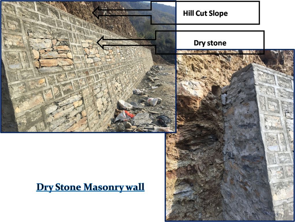
Here I am taking about only the Banded dry stone masonry wall which is very helpful for protection of a excavated slope in hilly terrain due to easy availability of major raw material as a stone. It is most cheaper than other works. The water is easily peculate between the stone so no water pressure developed behind the wall. It is cost effective as well as performed better in earthquake condition. It is repaired very quickly as compared to reinforced wall and other option.

Sketch for bonded stone masonry wall as a slope protection for 2-lane highway

we can use a Cement Banded dry stone masonry wall to protect hill side slope, median side as well as valley side slope due to easily availability of raw materials.

Design criteria of banded stone masonry wall:

  There are mainly four types of  load and pressure should be considered to built a
   banded stone masonry wall which are as follow-

• Self weight of banded stone masonry wall (SBC)
• Earth pressure acting on wall (Cut Slope soil/rock pressure)
• Water pressure (water pressure if any)
• Seismic load (seismic zone of the area where  wall is to be built)

After assessment of the above given point the design should be as follow based on  codal provision-

•    Width of wall foundation should be  B= 0.5*H + 0.3 (where H=Height of wall) to get
     desired SBC, top width should be 0.6 m up to 4 m height and 0.5 m more than 4 m
     height of wall.

•  Foundation should be inclined inward 1:3 to 1:6  to safe against overturning
•  keep the front better 1:2 to 1:6, keep back front straight up to 4 m, back front
   reduced more than 4 m to 8 m height.
• Coping placed 0.50 to 0.75 mm. sloping towards valley side.

• There is no need to provide horizontal PVC pipe for drainage as there is sufficient space between dry stone to flow the water.


Construction Methodology  for site:
  First we should ensure the desired excavation of cut slope is satisfactory or not
   than SBC must be ensure before laying PCC by Geo technical expert.

Check the Line and level as per drawing for PCC. PCC done 100mm to 300mm thick
   as per   strata.

• Wall foundation must be slopping inward 1:3 to 1:6 to escape overturning.


• Construction materials as Cement mortar should be used 1:4 and size of stone should not be 20*15*10 cm approximately and stone should be clean and clay free.

• Depth of foundation must be 1000 mm when rest on soil and 500 mm if rest on rock strata, depth generally should be 0.1*H + 0.3 .

• The wall should be constructed with 8 meter construction joint up to the coping as  per the given figure.

•  Compacted back fill should be done simultaneously as the height of wall increase, back fill materials should be granular or stone chips (well drained). The back fill layer should be place in such a manner that the back fill load on wall should be Zero. Top surface of back fill to be sealed by impervious 300 mm layer to prevent ingress of rain water.
• Drainage PVC pipe within the wall is not required as space between dry stone is sufficient to release the water pressure behind the wall.

• Coping should be done with 1:4 mortar 50-75 mm sloping towards valley side.

•  Road side drainage should be provided as per discharge quantity of water during monsoon.

• Cement sand mortar ratio should be 1:4


The following points should be remember:
The foundation area should be compacted properly before laying the PCC.
• If water surcharge is more than proper weep holes should be provided to release  ground water.
• Back filling should be placed properly.
• Mortar quality should be checked at regular interval and curing must be done as per standard.
• Man power should be well experienced in stone masonry works.
1.IRC:SP: 48,1998
2.IRC:40-2002
3. IRC:78-2014
4.IS:14458, Part3